AOS is a brand born from a collaborative partnership between AAC Clyde Space, ORBCOMM and Saab. Together we develop the next generation of space based VDES system marking the beginning of a new era in maritime communications. We call it Beyond Horizons.
Our main objective is to develop a solution providing unlimited global reach. We do that by connecting land, sea, air and space. Each collaborator contributing with its unique capability – AAC Clyde Space with smart satellite designs able to balance cost efficiency and performance requirements of future platforms; ORBCOMM in software design for smart navigation and communication solutions; and Saab with advanced land-, sea-, air- and space-based transponders and base stations.
We are now launching an in-depth series of articles called “Beyond Horizons”. Here we go deeper into different user cases explaining the benefits of moving towards satellite-based VDES. First a short recap on the definition of AIS and VDES.
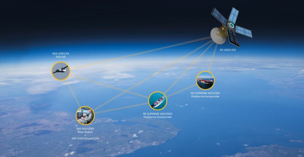
The Automatic Identification System (AIS) is a ship-to-ship collision avoidance system providing communication of position, speed and other ship data via a Very High Frequency (VHF) data link network. The number of marine vessels using AIS has gradually increased resulting in overload of the two channels carrying the AIS transmissions. The next generation AIS – called the VHF Data Exchange System (VDES) is under development. VDES preserves the original function of AIS and provides four additional channels for communication. VDES can be terrestrial- or satellite-based, and preferably both combined into a VDES network able to form a mesh providing unlimited global coverage.
The primary benefits of VDES compared to AIS are as follows:
- Increased capacity for data communication with VDE-Terrestrial (up to 32 times the capacity of AIS).
- Increased coverage area provided by VDE-Satellite, including the Arctic.
- Ability to layer in cyber-security.
- Provides a backup Positioning Navigation and Timing or Global Navigation Satellite System-denied environments and the ability to de-spoof AIS.
In this first article we will explain how VDES will improve safety and efficacy in monitoring and planning of dense maritime traffic along shore lines. Shore line traffic is monitored and controlled by so called Vessel Traffic Services (VTS) i.e. shore-side systems ranging from the provision of simple information messages to ships, such as position of other traffic or meteorological hazard warnings, to vessel management in a densely trafficked port or waterway.
VTS – dependent on efficient data transmission for maintained safety
VTSs monitor vessel movements within a limited area, commonly high traffic ports. Safety of Life at Sea (SOLAS) defines VTS as “helping to contribute to safety of life at sea, safety and efficiency of navigation and protection of the marine environment, adjacent shore areas, work sites and offshore installations from possible adverse effects of maritime traffic.” Authorities use AIS data combined with other land-based sensors to track vessel traffic including their intentions. VTS then use this data to make decisions on traffic movements within the VTS
geographic area. VTS service applications help VTCs (Vessel Traffic Centres) to control and monitor the increasing traffic volumes. Traffic jams at sea is a major challenge with severe negative effects on the climate as well as economic effects on vessel owners and the port management industry. It’s therefore critically important to keep looking for smarter, greener and safer technological solutions.
Route Exchange – improved efficacy and reduced carbon footprint
One solution that enhances safety is Route Exchange where a vessel transmits its intended route to nearby vessels. These vessels then return their intended routes. This constitutes a substantial improvement over AIS position reports since it allows ships to broadcast not just their position, course and speed to avoid collision, but also their intended route allowing for advanced situational awareness. This approach reduces risk of misunderstandings and in addition, provides decision support when detecting other vessels or new potentially danger areas.
The use of Route Exchange could also assist with VTS operations, whereby information on routes can be exchanged with shore personnel. In the longer run, the shore unit can provide optimized routes to the ship. The ship transmits the intended route from their voyage plan in ECDIS whereby the shore system will then optimize the route by analyzing information from shore including other vessels. When analysis is finished the recommended optimized route is sent back to the ship. Optimized route planning allows the ship to get from point A to B with minimum resources thereby reducing the climate footprint. This is why optimized routing is also called green routing.
AIS is currently used in VTS areas to collect data on ships’ position and identity. Route exchange as envisioned with VDES does not yet exist. There is however AIS-based Application Specific Message (ASM) route exchange, a more limited capability. For example in highly dense areas where the collision risk is elevated, the active route of a ship is transmitted using an AIS ASM.
VDES – adding critical bandwidth to VTS
So which are the benefits with VDES as the carrier of data between marine vessels and shore-based authorities? To set the scene, one must first understand that VTS areas are growing denser and the level of complexity is increasingly challenging to manage. Vessels often navigate in close proximity to each other and frequently have navigational restrictions such as draft, height, beam, and length that limit their ability to maneuver within these areas. In addition, their movements may be dependent on local tides, currents and other meteorological conditions that authorities and mariners need to consider when making navigational decisions. In an effort to maximize cargo capacity, some ships have also grown larger. Another parameter adding to the complexity is that shipping companies are moving towards autonomous shipping systems. Both factors combined result in reduced margin of error within VTS areas putting high demands on secure and reliable data communication links. With AIS being an overloaded system from start, VDES would substantially increase the bandwidth available to manage critical data within the VTS area. This will in turn reduce the risk of accidents due to lack of data capacity. The data capacity limitations of today’s AIS system is acute and in a recent global survey 97% claimed that they cannot rely on AIS data only but they need to combine radar data and AIS data to get a complete marine traffic image.
VDES Main VTS and Route Exchange User Cases
There are four main VDES use cases with VTS and Route Exchange proposed by IALA (International Association of Marine Aids to Navigation and Lighthouse Authorities). They are the following:
- Information Service. Information Service is provided by broadcasting information at fixed times and intervals or when deemed necessary by the VTS, or at the request of a vessel. The information provided may include safety information. Additional information could include specific limitations for navigation in the VTS area (for example maneuverability limitations; draft restrictions; channel closures; diving operations). Information exchange may be integrated with, and portrayed on, external systems ashore and on-board.
- Navigational Assistance Service. The navigational assistance service (NAS) is defined by IMO as ‘a service to assist on-board navigational decision-making and to monitor its effects.’ NAS may be provided on request by a vessel in circumstances such as equipment failure or navigational unfamiliarity. VDES could be used in the exchange of information during the provision of NAS. Information exchange may be integrated with, and portrayed on, external systems ashore and on-board.
- Traffic Organization Service. The traffic organization service (TOS) is defined by IMO as ‘a service to prevent the development of dangerous maritime traffic situations and to provide for the safe and efficient movement of vessel traffic within the VTS area.’ The purpose of the TOS is to prevent hazardous situations from developing and to ensure safe and efficient navigation through the VTS area, VDES could be used to exchange this information. Information exchange may be integrated with, and portrayed on, external systems ashore and on-board.
In summary, VDES provides much needed improvement to current AIS-based Vessel Traffic Services (VTS). The problem of today’s limited data capacity poses a serious threat to safety and as traffic volumes continue to rise this will become an even bigger challenge in the future.
The substantially increased bandwidth of VDES opens up for VTS services enabling a broader array of applications which, in addition to fulfilling baseline safety requirements, adds the potential for advanced navigation services such as Route Exchange. Route Exchange optimizes the use of resources both for vessel owners and the port management industry allowing for substantial savings in terms of fuel, maintenance and labor.
In AOS we believe in a greener, smarter and safer maritime world. New e-Navigation services require a fast, accurate and safe technological backbone capable of handling high-volume data streams. This is where VDES excels compared to today’s restrained AIS system. We call it Beyond Horizons. By combining advanced small-scale satellites, smart routing communication software and pioneering transponders able to connect land, sea, air and space – VDES combines into an advanced hardware and software solution ready to meet the demands of tomorrow’s seafarers.